Trail Walking Saint-Martin (VS) - Cabane des Becs de Bosson - Photo
 jipi2
jipi2

User

© OpenStreetMap contributors
Length
Length
15.7 km
Max alt
Max alt
2979 m
Uphill gradient
Uphill gradient
1261 m
Km-Effort
Km-Effort  
33 km
Min alt
Min alt
1802 m
Downhill gradient
Downhill gradient
1264 m
Boucle
Boucle
Yes
Creation date :
2015-12-30 00:00:00.0
Updated on :
2015-12-30 00:00:00.0

(0 Reviews)

Walking
Walking
6h26
Difficulty : Medium

Scan this QR Code to open this trail in the SityTrail application

FREE GPS app for hiking

Logo SityTrail SityTrail

IGN / Geographical institutes

Download SityTrail from the App Store Download SityTrail from Google Play

Logo SityTrail SityTrail World

The world is yours!

Download SityTrail from the App Store Download SityTrail from Google Play Download SityTrail on Huawei AppGallery

About

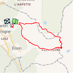
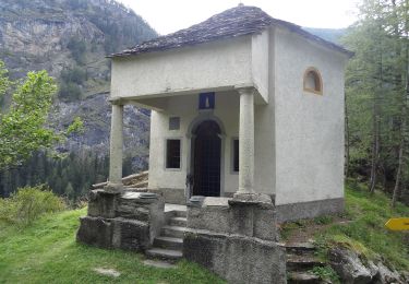
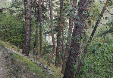
Trail Walking of 15.7 km to be discovered at Valais/Wallis, Hérens, Saint-Martin (VS). This trail is proposed by jipi2.

Description

Parc au bord de la route dans le virage

Elevation profile

Points of interest

Point of interest Saint-Martin (VS) -  - Photo
jipi2
SAINT-MARTIN (VS) 
Point of interest Saint-Martin (VS) - Pas de Lovegno - Photo
jipi2
SAINT-MARTIN (VS) 
Point of interest Saint-Martin (VS) -  - Photo
jipi2
SAINT-MARTIN (VS) 
Point of interest Saint-Martin (VS) - Pas de Lona - Photo
jipi2
SAINT-MARTIN (VS) 

Positioning

Country:
Switzerland
Region :
Valais/Wallis
Department/Province :
Hérens
Municipality :
Saint-Martin (VS)
Location:
Unknown
Start:(UTM)
381100 ; 5114282 (32T) N.

Trails nearby

Trail On foot Hérémence - Euseigne - fixme - Photo
On foot
PRO

On foot

Easy
Hérémence, Valais/Wallis, Hérens, Switzerland
3.2 km | 6.2 km-effort
1h 25min
No
Trail On foot Hérémence - Euseigne - Hérémence - Photo
On foot
PRO

On foot

Easy
Hérémence, Valais/Wallis, Hérens, Switzerland
5.2 km | 9.7 km-effort
2h 12min
No
Trail On foot Mont-Noble - La Combe - Nax - Photo
On foot
PRO

On foot

Easy
Mont-Noble, Valais/Wallis, Hérens, Switzerland
6.3 km | 9.8 km-effort
2h 13min
No
Trail On foot Mont-Noble - Le Louché Lac - Col du Cou - Photo
On foot
PRO

On foot

Easy
Mont-Noble, Valais/Wallis, Hérens, Switzerland
3.7 km | 6.3 km-effort
1h 26min
No
Trail On foot Mont-Noble - Le Louché-L'Ar du Tsan Lac (A) - Photo
On foot
PRO

On foot

Easy
Mont-Noble, Valais/Wallis, Hérens, Switzerland
3.6 km | 5 km-effort
1h 8min
No
Trail On foot Mont-Noble - L'Ar du Tsan - Le Louché Lac (B) - Photo
On foot
PRO

On foot

Easy
Mont-Noble, Valais/Wallis, Hérens, Switzerland
4.1 km | 8 km-effort
1h 49min
No
Trail On foot Evolène - Volvovron - L'A Vieille - Photo
On foot
PRO

On foot

Easy
Evolène, Valais/Wallis, Hérens, Switzerland
4.2 km | 10.3 km-effort
2h 20min
No
Trail Nordic walking Hérémence - vallée de la borgne - Photo
Nordic walking
suzanne.bron

Nordic walking

Very easy
Hérémence, Valais/Wallis, Hérens, Switzerland
10.8 km | 15.4 km-effort
5h 22min
No
Trail Walking Saint-Martin (VS) - Trajet du 28.10.21 - Photo
Walking
Leemans

Walking

Very difficult
Saint-Martin (VS), Valais/Wallis, Hérens, Switzerland
14.8 km | 28 km-effort
6h 17min
Yes


Close
My subscriptions